Cross Island Line Map: All CRL Stations, Phases and the Hougang Interchange
The Cross Island Line map in words and tables: every announced station by phase, target opening years, interchanges, and what the Hougang stop changes.
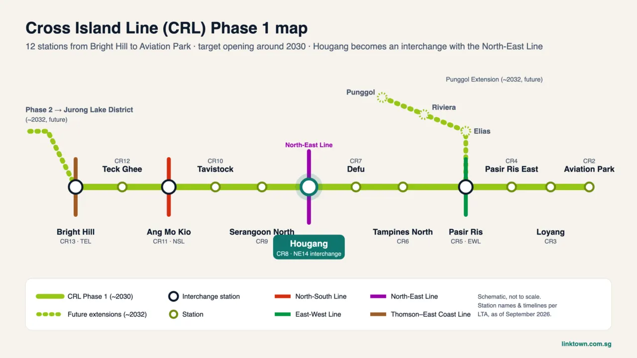
People search for a Cross Island Line map because the line is long, built in stages and full of new station names. This guide sets out the map in words: every station LTA has named, grouped by phase, with interchanges and target years. We also explain why the Hougang stop matters for anyone looking at LinkTown Residences (Hougang Central Residences), which is planned above Hougang MRT.
We have not reproduced LTA’s map image. For the graphic, see LTA’s Cross Island Line page. Target years below are as LTA stated them in 2025 and 2026 and may change.
The line in numbers
- Length: more than 50 km when complete, fully underground, the longest such line in Singapore.
- Stations: 27 in total, including 11 interchanges.
- Codes: main line stations use CR; the Punggol branch uses CP.
- Ridership: LTA expects over 600,000 daily trips in the early years, rising past one million in the long term.
How the map is shaped
Picture a long arc across the island. It starts near Changi in the east, swings north-west through Pasir Ris, Tampines North and Hougang, runs west across Serangoon North and Ang Mo Kio, dips under the central nature area, and ends in the far west at Jurong and Gul Circle. A short branch leaves Pasir Ris and heads north-west to Punggol. The four sections are built as separate phases.
Phase 1 (CRL1): Aviation Park to Bright Hill, target 2030
Phase 1 is 29 km with 12 stations. It is the section that serves Hougang.
| Code | Station | Connects to | Stops from Hougang |
|---|---|---|---|
| CR2 | Aviation Park | – | 6 |
| CR3 | Loyang | – | 5 |
| CR4 | Pasir Ris East | – | 4 |
| CR5 | Pasir Ris | East-West Line; later the Punggol Extension | 3 |
| CR6 | Tampines North | – | 2 |
| CR7 | Defu | – | 1 |
| CR8 | Hougang | North East Line (NE14) | 0 |
| CR9 | Serangoon North | – | 1 |
| CR10 | Tavistock | – | 2 |
| CR11 | Ang Mo Kio | North-South Line | 3 |
| CR12 | Teck Ghee | – | 4 |
| CR13 | Bright Hill | Thomson-East Coast Line | 5 |
LTA says Phase 1 will serve more than 100,000 households and open up easier trips to Changi Beach Park and Bishan-Ang Mo Kio Park. Its March 2026 update noted that several stretches of tunnelling had been completed.
CRL Punggol Extension: target 2032
A 7.3 km branch with four stations, three of them interchanges:
| Code | Station | Connects to |
|---|---|---|
| CP1 | Pasir Ris | East-West Line, CRL main line |
| CP2 | Elias | – |
| CP3 | Riviera | Punggol LRT |
| CP4 | Punggol | North East Line, Punggol LRT |
When LTA announced the branch, it said a Punggol to Pasir Ris trip would take within 15 minutes, against about 40 minutes by bus. Our Punggol transport guide covers the interchanges at that end.
Phase 2 (CRL2): Bright Hill to Jurong Lake District, target 2032
About 15 km and six underground stations running west. Construction began in July 2025.
| Code | Station | Connects to |
|---|---|---|
| CR14 | Turf City | – |
| CR15 | King Albert Park | Downtown Line |
| CR16 | Maju | – |
| CR17 | Clementi | East-West Line |
| CR18 | West Coast | – |
| CR19 | Jurong Lake District | – |
LTA says CRL King Albert Park will be the deepest station on the network, at about 50 metres.
Phase 3 (CRL3): Jurong Lake District to Gul Circle, late 2030s
About 10 km with four underground stations (CR20 to CR23), linking to the Jurong Region Line and ending at Gul Circle on the East-West Line. LTA says construction should start in 2027. A second CRL depot is planned on the former Raffles Country Club site.
Timeline at a glance
| Section | Stations | Target |
|---|---|---|
| Phase 1 | 12 (CR2 to CR13) | 2030 |
| Punggol Extension | 4 (CP1 to CP4) | 2032 |
| Phase 2 | 6 (CR14 to CR19) | 2032 |
| Phase 3 | 4 (CR20 to CR23) | late 2030s |
Why the Hougang interchange matters
Today, a Hougang resident heading east or west usually rides the North East Line to Serangoon and changes to the Circle Line, or takes a bus. With Hougang as an NEL and CRL interchange, the map opens up in two new directions from the town centre:
- East: Defu’s industrial estate, Tampines North, Pasir Ris and the Loyang and Changi aviation cluster, without going through Serangoon.
- West: Serangoon North, Ang Mo Kio for the North-South Line and Bright Hill for the Thomson-East Coast Line, and later, from 2032, on to Clementi and Jurong Lake District.
- Relief for the NEL: some trips that now squeeze through Serangoon should be able to use the CRL instead.
Stop counts are not travel times. The actual journey depends on train frequency and walking inside the new interchange, which LTA has not detailed. Our Hougang MRT guide covers the station as it works today.
What it means for LinkTown Residences
LinkTown Residences is the residential part of the Hougang Central integrated development, planned with a direct link to Hougang MRT and a new bus interchange. Completion is expected around 2030 to 2031, which lines up with the CRL Phase 1 target, though both dates can shift. Our CRL opening date guide looks at how firm the 2030 target is. Buyers of Hougang Central Residences would be looking at a home above what should become one of the north-east’s busier interchanges.
To be announced: how the blocks will link to the NEL and CRL platforms, and the development’s exact completion date. Sales are expected in early 2027, and UOL’s August 2026 results guide a 2H 2027 launch. See the launch date page for updates.
More on the area: the location page, the Hougang master plan and our Punggol Digital District guide.
Sources checked September 2026: LTA Cross Island Line page; LTA news releases on CRL2 (July 2025), the Punggol Extension (March 2020) and the next phase of rail development (March 2026); station codes cross-checked with Land Transport Guru.
Register to get LinkTown Residences site plan and launch details as soon as they’re released.
Frequently asked questions
How many stations are on the Cross Island Line?
LTA says the full line will have 27 stations over more than 50 km, with 11 interchanges, making it Singapore’s longest fully underground line.
Which are the Cross Island Line Phase 1 stations?
Aviation Park, Loyang, Pasir Ris East, Pasir Ris, Tampines North, Defu, Hougang, Serangoon North, Tavistock, Ang Mo Kio, Teck Ghee and Bright Hill (CR2 to CR13). LTA targets 2030.
When will the CRL open at Hougang?
Hougang (CR8) is part of Phase 1, which LTA targets to open in 2030. Dates can move, so check LTA’s Cross Island Line page.
Does the Cross Island Line go to Punggol?
Yes, through the CRL Punggol Extension: Pasir Ris, Elias, Riviera and Punggol. LTA targets 2032 for this 7.3 km branch.
More neighbourhood guides
All guides
Neighbourhood
P1 Registration 2027: The Phases, What Changes, and Planning Around Hougang Central
P1 registration 2027 explained: the phases, the Phase 2C change from 40 to 60 places, distance bands and notes for Hougang families.
Neighbourhood
Living in Hougang: What the Town Is Like, Area by Area, for Residents
What living in Hougang is really like: sub-areas, food, transport, pros and cons, and who the town suits best.

Neighbourhood
Punggol Park: The Lake Loop, Facilities and the Route from Hougang Central
Punggol Park explained: where it really is, the lake loop, facilities, parking and the walk from Hougang Central.